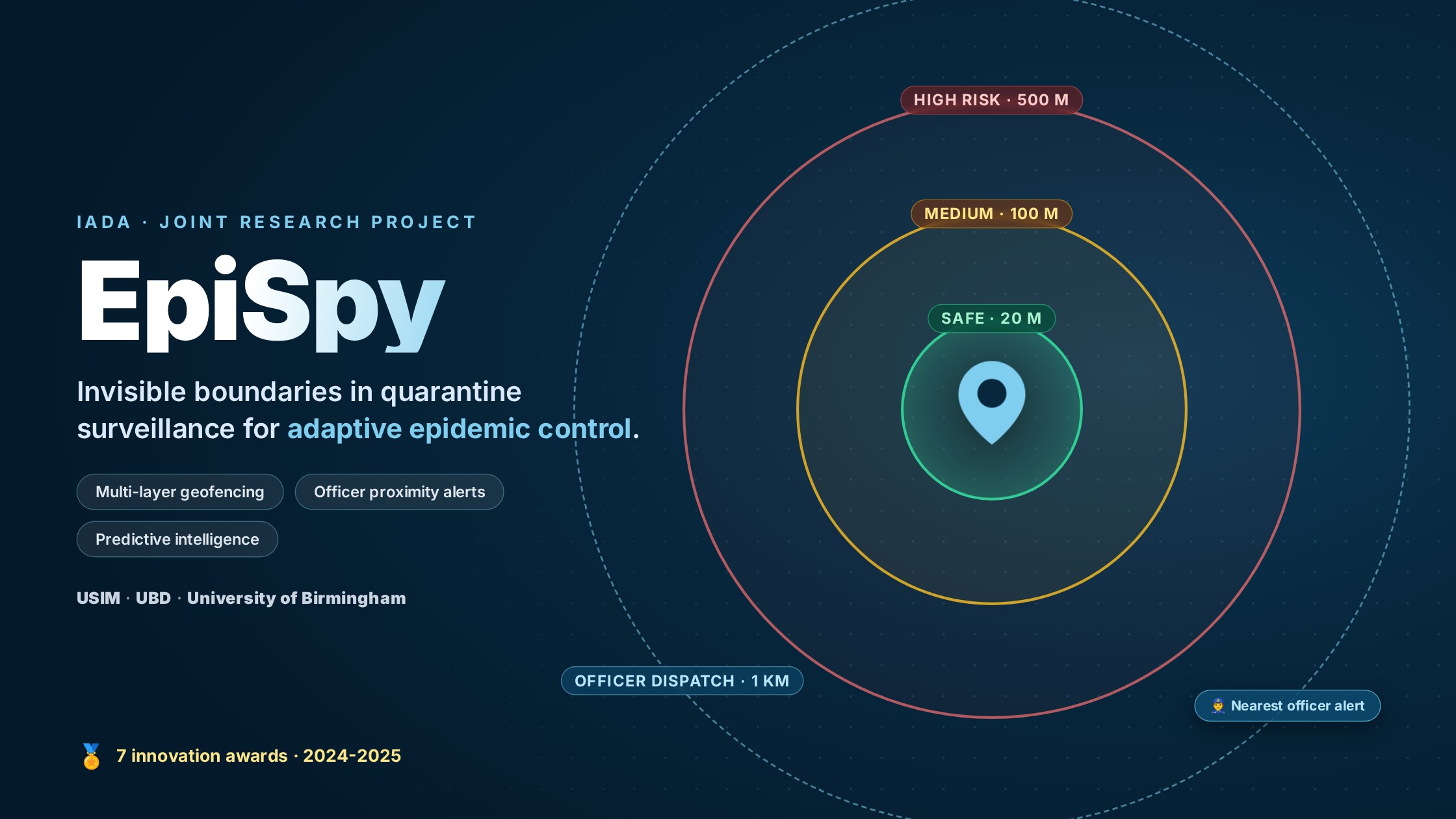
EpiSpy is an epidemic-surveillance research project that rethinks how quarantine is monitored and enforced. Instead of relying on passive contact tracing, EpiSpy draws multi-layer geofence boundaries around each quarantined individual and routes breach alerts to the nearest enforcement officer in real time. The project is a collaboration between Universiti Sains Islam Malaysia (USIM), Universiti Brunei Darussalam (through IADA), and the University of Birmingham, and has won seven innovation awards across 2024 and 2025.
Why EpiSpy
Contact-tracing apps deployed during COVID-19 could record encounters, but they could not enforce isolation: compliance depended on self-discipline, and health authorities had no scalable way to know when, where, and how seriously quarantine orders were being broken. EpiSpy closes that gap. It combines user-zone analytics with officer proximity surveillance, so a detected violation flows directly into a field response. Alert filtering keeps officers focused on genuine, high-priority breaches.
How it works
Presented at the 2026 International Conference on Data Science, Machine Learning, and Intelligence (DataSciMI), the system is built from four synchronized algorithms:
-
User distance calculation: the live distance between a quarantined user and their assigned quarantine location
-
Multi-layer geofencing: concentric risk zones with time-aware violation logic
-
Officer distance estimation: the proximity of enforcement officers to each monitored user
-
Officer surveillance activation: automatic alerting of the nearest officer when a serious or prolonged breach occurs
ZoneTriggerResponseSafewithin 20 m of the quarantine locationNormal monitoringMedium riskbeyond 20 m, up to 100 mOne-hour violation timer starts, user notifiedHigh riskbeyond 100 m, up to 500 mHigh-risk alert raisedOfficer dispatchofficer within 1 km of the userNearest officer alerted on a serious or prolonged breach
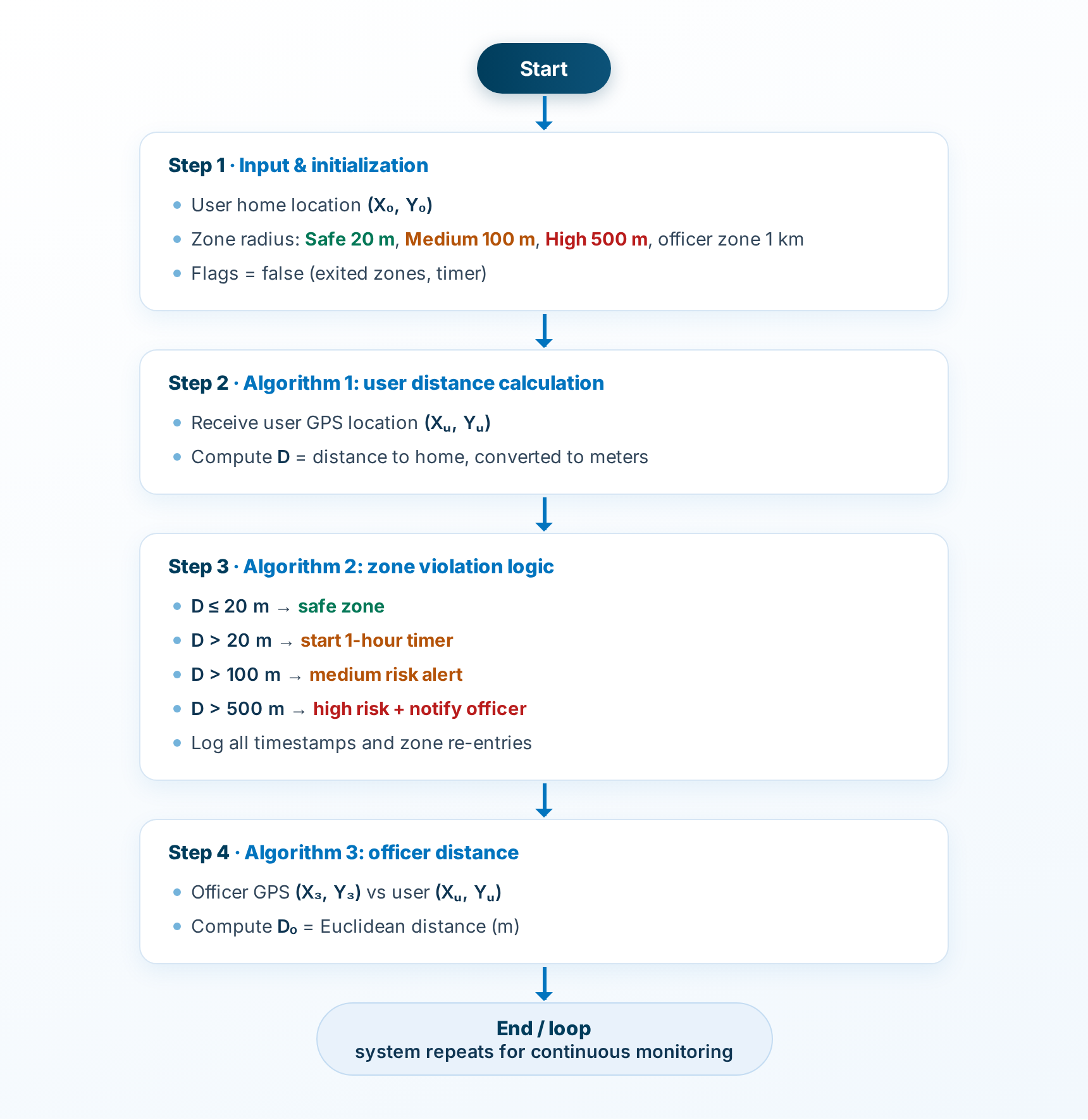
EpiSpy’s monitoring loop: initialization, user distance calculation, zone-violation logic, and officer distance (redrawn from the DataSciMI 2026 paper).
Re-entry logging and the one-hour timer suppress false alarms from brief excursions and GPS drift, and an officer-facing dashboard filters alerts so field officers see only what matters. Ongoing work targets Wi-Fi and Bluetooth hybrid localization, edge computing, and differential privacy for stronger data protection.
The geofencing line of work began in 2020 with Geo-COVID, a movement-monitoring framework for Malaysia’s Movement Control Order developed with the University of Messina.
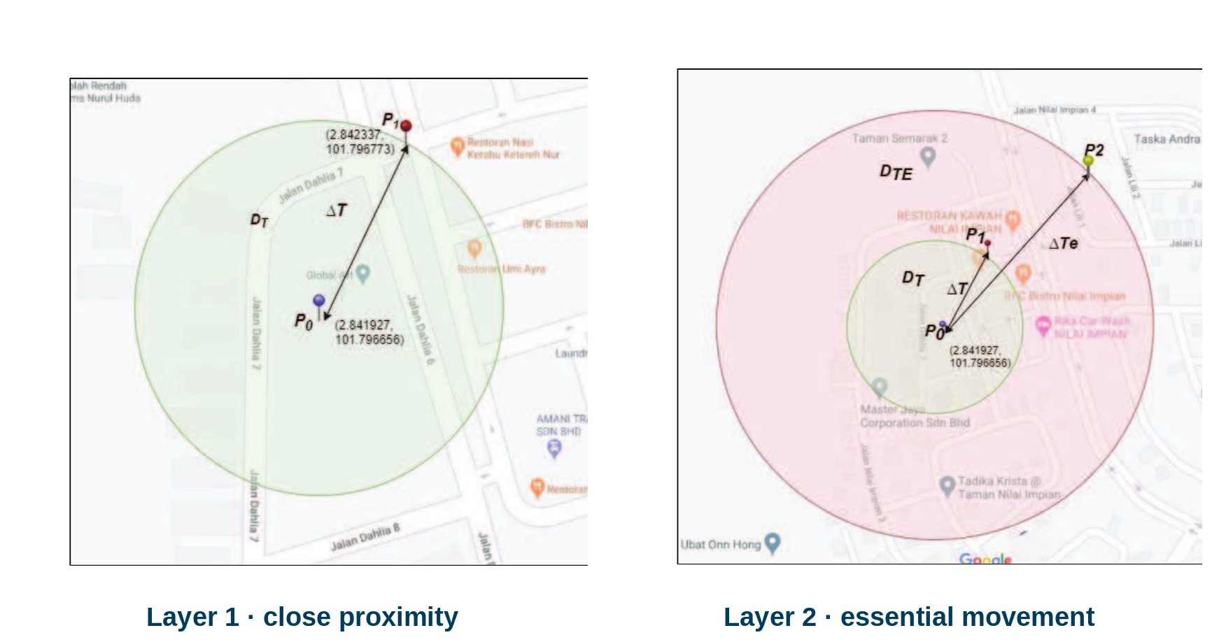
Geo-COVID’s two geofence layers around a quarantine location: close-proximity monitoring (left) and the wider essential-movement boundary (right), from the 2020 paper.
Predictive public-health intelligence
Around the surveillance core, the team is building the wider epidemic-intelligence layer:
-
SEIR forecasting of infectious-disease spread across 12 Malaysian states, motivating targeted, area-specific controls instead of blanket lockdowns
-
Localization of the WHO EIOS platform, integrating state-level data from the Google COVID-19 Open Data Repository to bring epidemic intelligence from country level down to local outbreaks
-
Two systematic reviews mapping the field: technological trends in epidemic intelligence (69 studies, PeerJ Computer Science) and big-data analytics for proactive infectious-disease prevention (846 articles screened under PRISMA, Journal of Big Data)
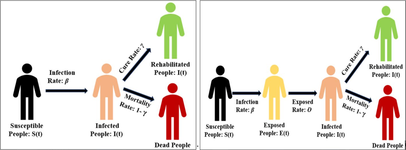
The compartmental models behind the forecasting work: classic SIR (left) and SEIR (right), from the Journal of Big Data review.
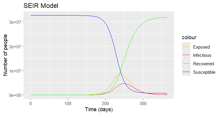
SEIR projection of Malaysian COVID-19 dynamics over 991 days: susceptible, exposed, infectious, and recovered populations (MJoSHT, 2025).
Recognition
EpiSpy has earned seven awards across five competitions and exhibitions:
-
Platinum Award, Gold Award, and Top 10 Best Poster Award, International Future Innovators Challenge 2025 (IFIC 2025)
-
Gold Award, Category C: Professional and Industry Participants, 2nd International Development, Research and Innovation Exhibition (iDRIVE ’25), organized by Universiti Tun Hussein Onn Malaysia, Pagoh Higher Education Hub
-
Gold Award, International Borneo Innovation, Exhibition and Competition (IBIEC ’25)
-
Silver Award, Final Year Project and Postgraduate Research and Innovation Poster Competition (RIPC ’25)
-
Gold Award, Science and Technology Research Expo (SCITEX ’24), Universiti Sains Islam Malaysia
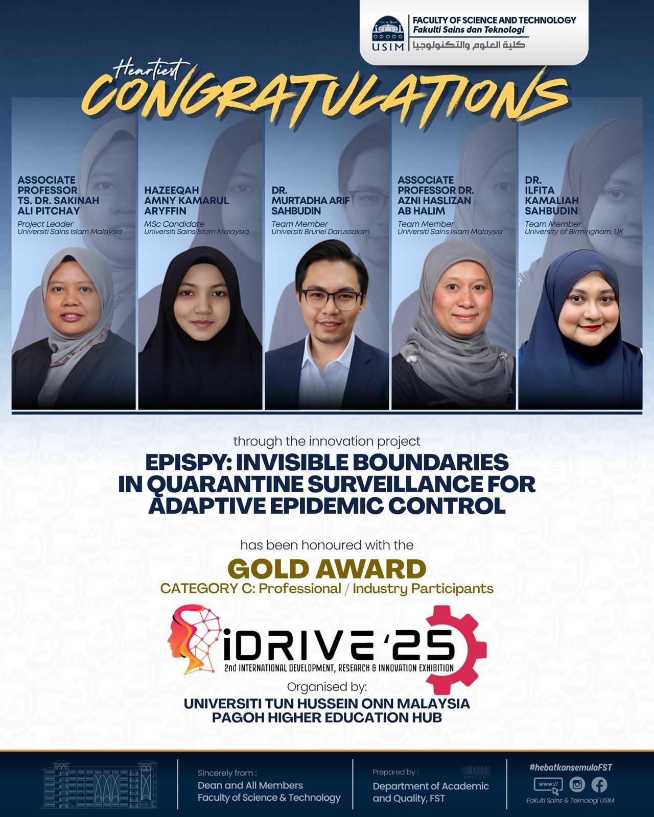
USIM’s congratulations to the EpiSpy team on the iDRIVE ’25 Gold Award.
Research team
-
Dr. Murtadha Arif Sahbudin, Universiti Brunei Darussalam (IADA)
-
Assoc. Prof. Ts. Dr. Sakinah Ali Pitchay, project leader, Universiti Sains Islam Malaysia
-
Hazeeqah Amny Kamarul Aryffin, MSc candidate, Universiti Sains Islam Malaysia
-
Nuha Rahim, Universiti Sains Islam Malaysia
-
Assoc. Prof. Dr. Azni Haslizan Ab Halim, Universiti Sains Islam Malaysia
-
Dr. Ilfita Kamaliah Sahbudin, University of Birmingham
The research is supported by the Malaysian Ministry of Higher Education under Fundamental Research Grant Scheme FRGS/1/2023/ICT03/USIM/02/3.
Publications and sources
-
Pitchay, S. A., Kamarul Aryffin, H. A., Sahbudin, M. A. B., and Ab Halim, A. H. (2026). EPISPY: Integrating User-Zone Analytics and Officer Proximity Surveillance for Smart Pandemic Response. 2026 International Conference on Data Science, Machine Learning, and Intelligence (DataSciMI). doi:10.1109/DataSciMI67380.2026.11523969
-
Kamarul Aryffin, H. A., Sahbudin, M. A. B., Pitchay, S. A., Ab Halim, A. H., and Sahbudin, I. (2025). Technological trends in epidemic intelligence for infectious disease surveillance: a systematic literature review. PeerJ Computer Science. doi:10.7717/peerj-cs.2874
-
Nuha, N., Pitchay, S. A., Ab Halim, A. H., Sahbudin, M. A. B., and Sahbudin, I. (2025). Beyond the outbreak: a review of big data analytics in proactive infectious disease prevention for risk mitigation for COVID-19. Journal of Big Data. doi:10.1186/s40537-025-01245-z
-
Rahim, N., Pitchay, S. A., Sahbudin, M. A. B., Azni, A. H., and Sahbudin, I. K. (2025). Forecasting Public Health Risks in Malaysia: Insights from SEIR Modelling of Infectious Diseases. Malaysian Journal of Science, Health & Technology. doi:10.33102/mjosht.v11i1.460
-
Kamarul Aryffin, H. A., Pitchay, S. A., Sahbudin, M. A. B., Azni, A. H., and Sahbudin, I. K. (2025). Advancing Localized Public Health Surveillance in Malaysia by Enhancing EIOS with Google COVID-19 Data Integration. Malaysian Journal of Science, Health & Technology. doi:10.33102/mjosht.v11i1.455
-
Kamarul Aryffin, H. A., Sahbudin, M. A. B., Pitchay, S. A., Azni, A. H., and Sahbudin, I. K. (2024). Direction of Enhancing Epidemic Intelligence From Open Source (EIOS) For Localized COVID-19 Management in Malaysia. Conference paper.
-
Sahbudin, M. A. B., Pitchay, S. A., and Scarpa, M. (2020). GEO-COVID: Movement Monitoring Based on Geo-Fence Framework for COVID-19 Pandemic Crisis. Advances in Mathematics: Scientific Journal. doi:10.37418/amsj.9.9.85
Find more from IADA researchers on the Publications page.