The UBD Climate Change Modelling Consortium is a national research initiative to develop high-resolution climate projections and climate-related multi-hazard maps that support Brunei’s National Adaptation Plan (NAP). Led by Universiti Brunei Darussalam together with the Brunei Climate Change Office and partners, it brings climate, ocean, flood, and high-performance computing expertise into one programme so that Brunei has its own evidence base for climate adaptation.
The urgency of climate action
Global warming has already reached about 1.55°C above pre-industrial levels, and current trends point to a rise of around 3°C by 2100. Brunei is already seeing heavier rainfall, flooding, landslides, dry spells, and forest fires, while stronger ENSO events and rising sea levels raise the risk from extreme weather and coastal hazards. Every additional degree of warming escalates risk across all sectors.
Aligned with Brunei’s NAP and BNCCP
The consortium is built around national priorities. It strengthens evidence-based adaptation planning, enables hazard, exposure, and vulnerability assessments for the National Climate Vulnerability Assessment (NCVA), and supports whole-of-nation resilience through high-resolution datasets. This directly serves Strategy 8 (Adaptation) of the Brunei National Climate Change Policy (BNCCP): improving understanding of climate-related hazards, supporting sectoral risk assessment, and advancing national modelling capacity.
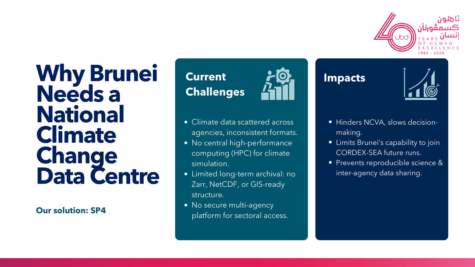
Solving Brunei’s climate data challenge
Existing regional projections are too coarse for a country Brunei’s size: CORDEX-SEA resolves to 25 km and CCRS V3 to 8 km, which cannot capture Brunei’s detailed topography and local dynamics. The consortium produces 1 km high-resolution projections, generates multi-hazard indices and maps, models inland and coastal flood risk, establishes Brunei’s national climate change data centre, and builds national capacity in climate modelling.
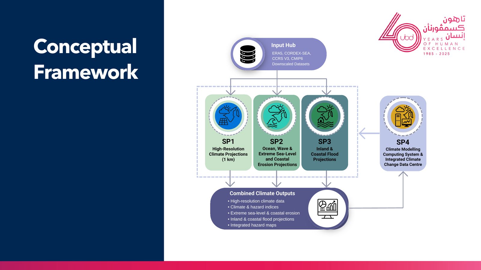
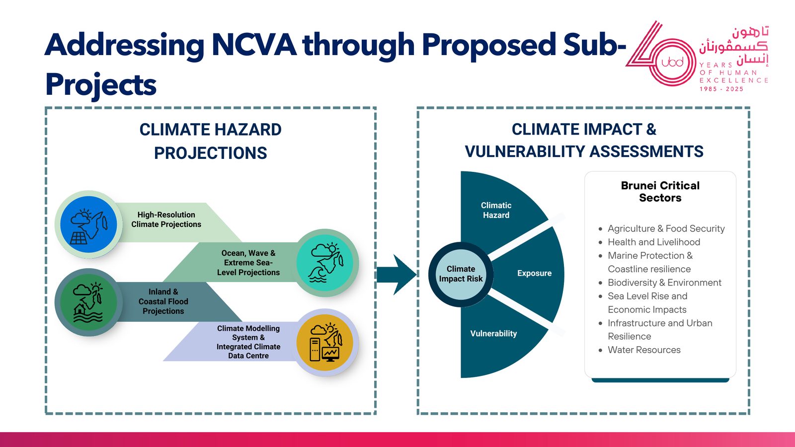
How the four sub-projects feed Brunei’s National Climate Vulnerability Assessment: climate hazard projections combine with exposure and vulnerability across seven critical sectors.
Four connected sub-projects
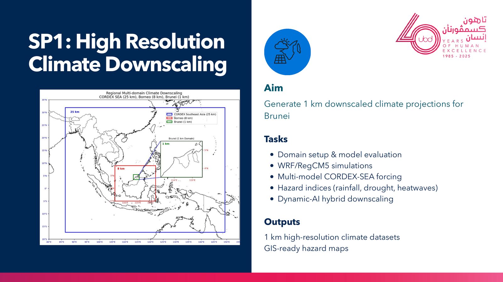
SP1: High-resolution climate downscaling. Generates 1 km downscaled climate projections for Brunei using WRF and RegCM5 simulations forced by multi-model CORDEX-SEA data, with hazard indices for rainfall, drought, and heatwaves, and a dynamic-AI hybrid downscaling approach. Outputs are 1 km climate datasets and GIS-ready hazard maps.
SP1 high-resolution downscaling: nested model domains from CORDEX-SEA (25 km) to Borneo (8 km) to a 1 km Brunei domain.
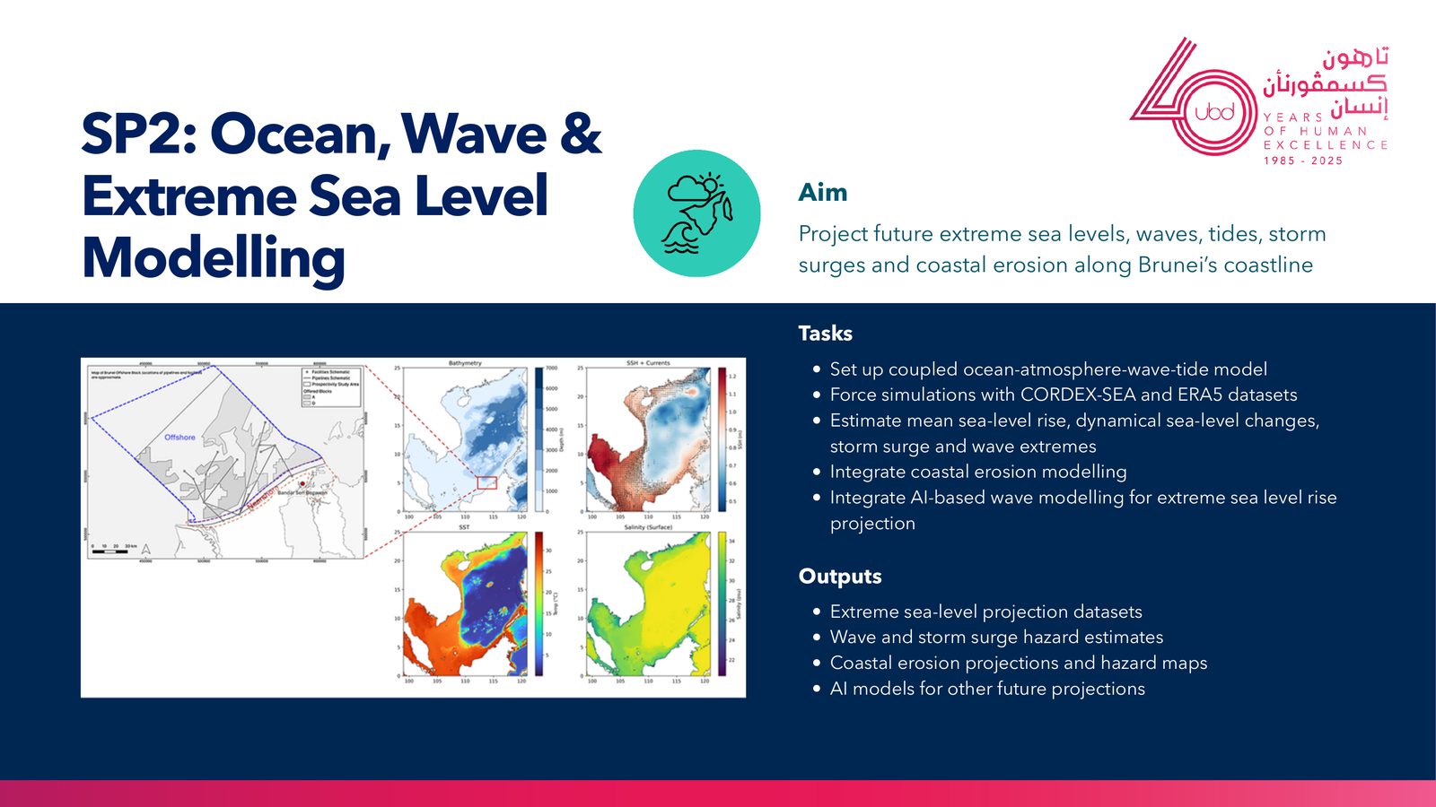
SP2: Ocean, wave, and extreme sea-level modelling. Projects future extreme sea levels, waves, tides, storm surges, and coastal erosion along Brunei’s coastline using a coupled ocean-atmosphere-wave-tide model forced by CORDEX-SEA and ERA5, with AI-based wave modelling. Outputs include extreme sea-level datasets, wave and storm-surge estimates, and coastal erosion hazard maps.
SP2 ocean, wave and sea-level modelling: bathymetry, sea-surface height and currents, sea-surface temperature, and salinity across Brunei’s waters.
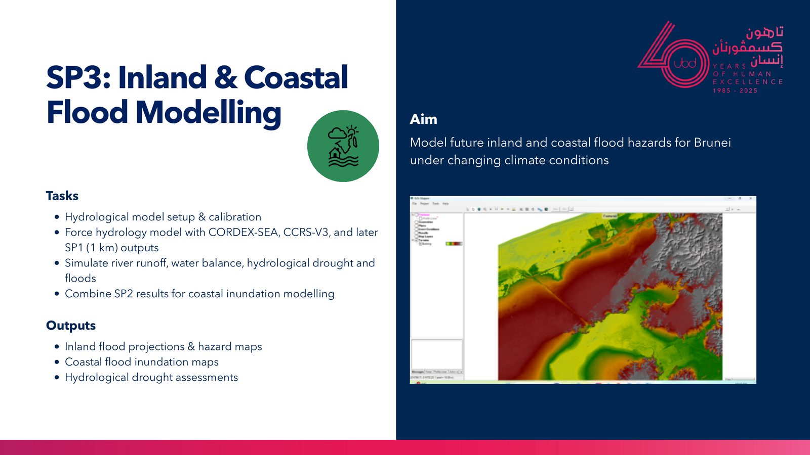
SP3: Inland and coastal flood modelling. Models future inland and coastal flood hazards under changing climate, combining a calibrated hydrological model (forced by CORDEX-SEA, CCRS V3, and later SP1 outputs) with SP2 results for coastal inundation. Outputs are inland and coastal flood projections, hazard maps, and hydrological drought assessments.
SP3 inland and coastal flood modelling: a flood inundation depth map produced from the coupled hydrological and coastal models.
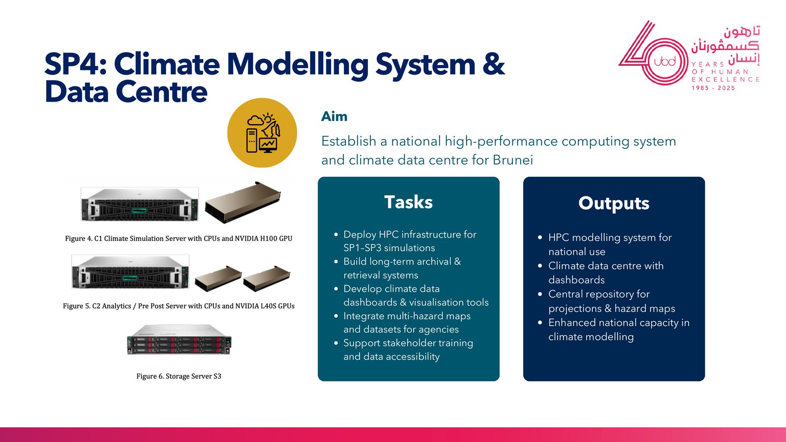
SP4: Climate modelling system and data centre. Establishes a national high-performance computing system and climate data centre: HPC infrastructure for the SP1 to SP3 simulations, long-term archival and retrieval, climate data dashboards, and integrated multi-hazard maps for agencies. It leaves Brunei with a central repository for projections and hazard maps and enhanced national modelling capacity.
SP4 climate modelling system: the proposed HPC stack, a climate simulation server (NVIDIA H100), an analytics server (NVIDIA L40S), and storage.
How it fits together
Shared input data (ERA5, CORDEX-SEA, CCRS V3, and downscaled CMIP6) feeds SP1, SP2, and SP3, whose combined outputs (high-resolution climate data, hazard indices, extreme sea-level and coastal erosion, flood projections, and integrated hazard maps) are produced and served through the SP4 computing system and data centre.
Conceptual framework: shared input data (ERA5, CORDEX-SEA, CCRS V3, CMIP6) flows through SP1 to SP3, with SP4 providing the computing and data centre that ties the outputs together.
National significance
The consortium transforms climate data for Brunei: it provides 1 km projections, the first of their kind for the country, fills critical data gaps in sea-level rise, waves, floods, and extremes, and establishes a National Climate Change Data Centre as a long-term national asset. It strengthens policy and national planning by directly supporting the NAP, BNCCP Strategy 8, and NCVA, and it builds long-term national capability in HPC, modelling, AI, and data governance, positioning Brunei as a regional leader in Southeast Asian climate modelling.
Consortium structure
Project leadership
-
Prof. Dr. Fredolin Tangang (Project Leader)
-
Dr Nurul Huda Mohd Ramli (Co-Leader)
Sub-project leaders
-
SP1: Dr. Nurul Huda Mohd Ramli
-
SP2: Dr. Novan Tofany Sugeng
-
SP3: Assoc Prof. Dr Stefan Gödeke
-
SP4: Dr. Murtadha Arif Bin Sahbudin
National collaborators
-
Brunei Climate Change Office (BCCO)
-
DEPR
-
Survey Department
-
BDMD
-
BSP
International partners
-
CORDEX-SEA network
-
CCRS Singapore
-
BMKG